在React Native App上之前使用的是通過Webview渲染一張Web地圖(https://map.qq.com/api/gljs?v=1.exp&key=XXX),這麼做的弊端就是速度慢而且不穩定,之前也用過高德地圖,為了和微信小程序保持一致,需要用騰訊地圖。
參考
騰訊地圖(IOS)
實現的功能
- 地圖中心點
- 縮放比例
- 地圖控件(指南針,比例尺子)
- 多個標記點
- 根據多點設置最合適的視野
- 初次渲染完成回調
- 點擊事件
- 主動移動地圖後返回中心點座標
申請apiKey
- 前往控制枱
- 應用管理
- 我的應用
- 創建應用
- 要選中SDK
配置騰訊地圖SDK
require_relative '../node_modules/react-native/scripts/react_native_pods'
require_relative '../node_modules/@react-native-community/cli-platform-ios/native_modules'

pod 'AlipaySDK-iOS'
pod 'Tencent-MapSDK' <= 添加這個
...
cd ios && pod install初始化地圖服務
參考:配置開發秘鑰、 隱私合規
創建TencentMap.h和TencentMap.m
- TencentMap.h
#import <React/RCTViewManager.h>
#import <Foundation/Foundation.h>
#import <UIKit/UIKit.h>
#import <QMapKit/QMapKit.h>

@interface TencentMap : RCTViewManager
@end
- TencentMap.m
#import "TencentMap.h"
#import <React/RCTUIManager.h>
#import <React/UIView+React.h>
#import <QMapKit/QMSSearchKit.h>

@implementation TencentMap

RCT_EXPORT_MODULE();

// 初始化Key
RCT_EXPORT_METHOD(initQMap: (NSString *)key) {
    [QMapServices sharedServices].APIKey = key;
    [QMSSearchServices sharedServices].apiKey = key;
    if ([QMapServices sharedServices].APIKey.length == 0 || [QMSSearchServices sharedServices].apiKey.length == 0){
      NSLog(@"Fail");
    } else {
      NSLog(@"Success");
    }
    return;
}

// 同意隱私協議
RCT_EXPORT_METHOD(agreementQMap) {
    [[QMapServices sharedServices] setPrivacyAgreement:YES];
    return;
}


@end
- React Native 在我的App同意隱私協議用户協議之後調用
import {NativeModules} from 'react-native';

const TencentMap = NativeModules.TencentMap;

const initNativeQQMap = () => {
    if (TencentMap && TencentMap["initQMap"]) {
        TencentMap["initQMap"](KEY); <= 之前申請的apikey
        if (TencentMap["agreementQMap"]) {
            TencentMap["agreementQMap"]();
        }
    }
}
創建地圖
創建TencentMapView.h和TencentMapView.m以及工具TencentMapUtils.h和TencentMapUtils.m
- TencentMapView.h
#import <UIKit/UIKit.h>
#import <QMapKit/QMapKit.h>
#import <React/RCTComponent.h>
#import <React/RCTViewManager.h>

@interface TencentMapView : UIView <QMapViewDelegate>

@property (nonatomic, strong) QMapView *mapView;
@property (nonatomic, assign) float zoomLevel; // 縮放級別
@property (nonatomic, assign) BOOL scaleViewFadeEnable; // 比例尺
@property (nonatomic, assign) BOOL showCompass; // 指南針
@property (nonatomic, strong) NSArray *coordinates; // 合適區域
@property (nonatomic, assign) CLLocationCoordinate2D mapCenter; // 中心點
@property (nonatomic, strong) NSArray *markers;  // 標記點
@property (nonatomic, strong) NSArray *linePoints;  // 線條點

@property (nonatomic, assign) BOOL isFirstRenderComplete; // 標記地圖首次渲染是否完成
@property (nonatomic, strong) NSMutableArray<QPointAnnotation *> *markerAnnotations; // 多個標記點
@property (nonatomic, strong) NSMutableArray<QPolyline *> *markerLines; // 多個線條點


@property (nonatomic, copy) RCTBubblingEventBlock onClick;    // 點擊事件回調
@property (nonatomic, copy) RCTBubblingEventBlock onMapLoad;    // 完成初次渲染
@property (nonatomic, copy) RCTBubblingEventBlock onRegionChange; // 移動回調

@end

@interface TencentMapViewManager : RCTViewManager
@end

@interface CustomPointAnnotation : QPointAnnotation

@property (nonatomic, strong) NSDictionary *userInfo; // 存儲額外數據

@end
- TencentMapView.m
#import "TencentMapView.h"
#import "TencentMapUtils.h"

@implementation CustomPointAnnotation

@end

@implementation TencentMapView

- (instancetype)init {
  self = [super init];
  if (self) {
    // 初始化地圖視圖
    self.mapView = [[QMapView alloc] initWithFrame:self.bounds];
    self.mapView.autoresizingMask = UIViewAutoresizingFlexibleWidth | UIViewAutoresizingFlexibleHeight;
    [self.mapView setMapType:QMapTypeStandard];
    [self.mapView setLogoScale:0.7];
    [self.mapView setZoomLevel:10];
    [self.mapView setCenterCoordinate:CLLocationCoordinate2DMake(39.9042, 116.4074) animated:YES];
    self.mapView.delegate = self; // 設置代理

    [self addSubview:self.mapView];
    _isFirstRenderComplete = NO;
    _markerAnnotations = [NSMutableArray array];
    _markerLines = [NSMutableArray array];
  }
  return self;
}

- (void)layoutSubviews {
  [super layoutSubviews];
  self.mapView.frame = self.bounds; // 確保地圖視圖填充父視圖
}

// props傳參數
#pragma mark - Props

// 設置中心點
- (void)setMapCenter:(CLLocationCoordinate2D)mapCenter {
  if (!CLLocationCoordinate2DIsValid(mapCenter)) {
    return;
  }
  _mapCenter = mapCenter;
  [self.mapView setCenterCoordinate:mapCenter animated:YES];
}

// 設置是否顯示指南針
- (void)setShowCompass:(BOOL)showCompass {
  _showCompass = showCompass;
  self.mapView.showsCompass = showCompass;
}

// 設置比例尺
- (void)setScaleViewFadeEnable:(BOOL)scaleViewFadeEnable{
  _scaleViewFadeEnable = scaleViewFadeEnable;
  self.mapView.showsScale = scaleViewFadeEnable;
}

// 設置地圖縮放級別
- (void)setZoomLevel:(float)zoomLevel {
  _zoomLevel = zoomLevel;
  [self.mapView setZoomLevel:zoomLevel animated:YES];
}

// 計算邊界矩形
- (void)setCoordinates:(NSArray *)coordinates {
  _coordinates = coordinates;
  if (coordinates.count > 0 && _isFirstRenderComplete) {
    [self adjustMapRegionToFitCoordinates];
  }
}

- (void) setLinePoints:(NSArray *)linePoints {
  _linePoints = linePoints;
  NSUInteger count = linePoints.count;
  if(count < 2){
    return; // 至少需要兩個點才能繪製路線
  }
  if(_markerLines.count > 0){
    [self.mapView removeOverlays:_markerLines];
    [_markerLines removeAllObjects];
  }
  CLLocationCoordinate2D routeCoordinates[count];
  for (NSUInteger i = 0; i < count; i++) {
    NSDictionary *point = linePoints[i];
    routeCoordinates[i] = CLLocationCoordinate2DMake(
                                                     [point[@"latitude"] doubleValue],
                                                     [point[@"longitude"] doubleValue]
                                                     );
  }
  QPolyline *polyline = [QPolyline polylineWithCoordinates:routeCoordinates count:count];
  [self.mapView addOverlay:polyline];
  [_markerLines addObject:polyline];
}

- (void)setMarkers:(NSArray *)markers {
  _markers = markers;

  // 移除舊的標記點
  if (_markerAnnotations.count > 0) {
    [self.mapView removeAnnotations:_markerAnnotations];
    [_markerAnnotations removeAllObjects];
  }

  // 添加新的標記點
  for (NSDictionary *marker in markers) {
    NSDictionary *coordinateDict = marker[@"coordinate"]; // 圖標位置
    NSDictionary *sizeDict = marker[@"size"]; // 圖標大小
    NSDictionary *offsetDict = marker[@"offset"]; // 偏移
    NSString *icon = marker[@"icon"]; // 網絡圖標 URL
    if(!icon){
      icon = @"";
    }
    if(!sizeDict){
      if(icon.length){
        sizeDict = @{@"width": @40, @"height": @40};
      } else {
        sizeDict = @{@"width": @36, @"height": @51};
      }
    }
    if (!offsetDict){
      offsetDict = @{@"x": @0, @"y": @0};
    }
    CustomPointAnnotation *pointAnnotation = [[CustomPointAnnotation alloc] init];
    pointAnnotation.coordinate = CLLocationCoordinate2DMake([coordinateDict[@"latitude"] doubleValue], [coordinateDict[@"longitude"] doubleValue]);
    pointAnnotation.userInfo = @{ @"icon": icon, @"size": sizeDict, @"offset": offsetDict, };
    // 將點標記添加到地圖中
    [self.mapView addAnnotation:pointAnnotation];
    [_markerAnnotations addObject:pointAnnotation];
  }
}

#pragma mark - Helper Methods

// 計算邊界矩形並調整地圖區域
- (void)adjustMapRegionToFitCoordinates {
  NSUInteger count = self.coordinates.count;
  if (count == 0) {
    return;
  }
  CLLocationCoordinate2D coordinates[count];
  for (NSUInteger i = 0; i < count; i++) {
    NSDictionary *coordinate = self.coordinates[i];
    CLLocationDegrees lat = [coordinate[@"latitude"] doubleValue];
    CLLocationDegrees lng = [coordinate[@"longitude"] doubleValue];
    coordinates[i] = CLLocationCoordinate2DMake(lat, lng);
  }
  QCoordinateRegion region = QBoundingCoordinateRegionWithCoordinates(coordinates, count);
  [self.mapView setRegion:region edgePadding:UIEdgeInsetsMake(30, 30, 30, 30) animated:YES];
}


#pragma mark - QMapViewDelegate

- (void)mapView:(QMapView *)mapView regionDidChangeAnimated:(BOOL)animated gesture:(BOOL)bGesture {
  if (bGesture) {
    // 獲取地圖視圖的中心點座標
    CLLocationCoordinate2D centerCoordinate = mapView.centerCoordinate;
    // 觸發事件,將中心點座標傳遞給 React Native
    if (self.onRegionChange) {
      self.onRegionChange(@{
        @"latitude": @(centerCoordinate.latitude),
        @"longitude": @(centerCoordinate.longitude)
      });
    }
  }
}

- (void)mapView:(QMapView *)mapView didTapAtCoordinate:(CLLocationCoordinate2D)coordinate {
  // 地圖點擊事件
  if (self.onClick) {
    self.onClick(@{
      @"latitude": @(coordinate.latitude), // 緯度
      @"longitude": @(coordinate.longitude) // 經度
    });
  }
}

- (void)mapViewFirstRenderDidComplete:(QMapView *)mapView {
  // 地圖首次渲染完成後調用
  _isFirstRenderComplete = YES;
  if (self.coordinates.count > 0) {
    [self adjustMapRegionToFitCoordinates];
  }
  if (self.onMapLoad){
    self.onMapLoad(@{});
  }
}

- (QOverlayView *)mapView:(QMapView *)mapView viewForOverlay:(id<QOverlay>)overlay {
  if ([overlay isKindOfClass:[QPolyline class]]) {
    QPolylineView *polylineView = [[QPolylineView alloc] initWithPolyline:overlay];
    polylineView.strokeColor = [UIColor colorWithRed:118/255.0 green:192/255.0 blue:111/255.0 alpha:1.0]; // 設置路線顏色
    polylineView.lineWidth = 6; // 設置路線寬度
    polylineView.borderWidth = 1;
    polylineView.borderColor = [UIColor whiteColor];
    return polylineView;
  }
  return nil;
}

- (QAnnotationView *)mapView:(QMapView *)mapView viewForAnnotation:(id<QAnnotation>)annotation {
  if ([annotation isKindOfClass:[CustomPointAnnotation class]]) {
    static NSString *annotationIdentifier = @"pointAnnotation";
    QPinAnnotationView *pinView = (QPinAnnotationView *)[self.mapView dequeueReusableAnnotationViewWithIdentifier:annotationIdentifier];
    if (pinView == nil) {
      pinView = [[QPinAnnotationView alloc] initWithAnnotation:annotation reuseIdentifier:annotationIdentifier];
      pinView.canShowCallout = NO;
      NSString *icon = ((CustomPointAnnotation *)annotation).userInfo[@"icon"];
      NSDictionary* size = ((CustomPointAnnotation *)annotation).userInfo[@"size"];
      NSDictionary* offset = ((CustomPointAnnotation *)annotation).userInfo[@"offset"];

      CGFloat width = [size[@"width"] doubleValue];
      CGFloat height = [size[@"height"] doubleValue];
      CGFloat offsetX = [offset[@"x"] doubleValue];
      CGFloat offsetY = [offset[@"y"] doubleValue];
      // 設置偏移(沒法準確)
      // pinView.centerOffset  = CGPointMake(offsetX, offsetY);
      // 默認圖標marker添加到Images.xcassets
      if (icon.length > 0) {
        [TencentMapUtils loadImageFromURL:icon completion:^(UIImage *image) {
          if (image) {
            CGSize newSize = CGSizeMake(width, height);
            UIImage *resizedImage = [TencentMapUtils resizeImage:image toSize:newSize];
            pinView.image = resizedImage;
          } else {
            // 設置默認marker大小
            UIImage *image = [UIImage imageNamed:@"marker"];
            CGSize newSize = CGSizeMake(width, height);
            UIImage *resizedImage = [TencentMapUtils resizeImage:image toSize:newSize];
            pinView.image = resizedImage;
          }
        }];
      } else {
        // 設置默認marker大小
        UIImage *image = [UIImage imageNamed:@"marker"];
        CGSize newSize = CGSizeMake(width, height);
        UIImage *resizedImage = [TencentMapUtils resizeImage:image toSize:newSize];
        pinView.image = resizedImage;
      }
    }
    return pinView;
  }

  return nil;
}

@end

// 導出地圖組件
@implementation TencentMapViewManager

RCT_EXPORT_MODULE(TencentMapView)

- (UIView *)view {
  return [[TencentMapView alloc] init];
}

RCT_EXPORT_VIEW_PROPERTY(mapCenter, CLLocationCoordinate2D)
RCT_EXPORT_VIEW_PROPERTY(zoomLevel, float)
RCT_EXPORT_VIEW_PROPERTY(scaleViewFadeEnable, BOOL)
RCT_EXPORT_VIEW_PROPERTY(showCompass, BOOL)
RCT_EXPORT_VIEW_PROPERTY(coordinates, NSArray)
RCT_EXPORT_VIEW_PROPERTY(markers, NSArray)
RCT_EXPORT_VIEW_PROPERTY(linePoints, NSArray)
RCT_EXPORT_VIEW_PROPERTY(onClick, RCTBubblingEventBlock)
RCT_EXPORT_VIEW_PROPERTY(onMapLoad, RCTBubblingEventBlock)
RCT_EXPORT_VIEW_PROPERTY(onRegionChange, RCTBubblingEventBlock)

@end
- TencentMapUtils.h
#import <UIKit/UIKit.h>

@interface TencentMapUtils : NSObject

// 調整圖片大小
+ (UIImage *)resizeImage:(UIImage *)image toSize:(CGSize)size;

// 從 URL 加載圖片
+ (void)loadImageFromURL:(NSString *)urlString completion:(void (^)(UIImage *))completion;

@end
- TencentMapUtils.m
#import "TencentMapUtils.h"
#import <Foundation/Foundation.h>

@implementation TencentMapUtils

// 調整圖片大小
+ (UIImage *)resizeImage:(UIImage *)image toSize:(CGSize)size {
    UIGraphicsBeginImageContextWithOptions(size, NO, 0.0);
    [image drawInRect:CGRectMake(0, 0, size.width, size.height)];
    UIImage *resizedImage = UIGraphicsGetImageFromCurrentImageContext();
    UIGraphicsEndImageContext();
    return resizedImage;
}

// 從 URL 加載圖片
+ (void)loadImageFromURL:(NSString *)urlString completion:(void (^)(UIImage *))completion {
    NSURL *url = [NSURL URLWithString:urlString];
    if (!url) {
        completion(nil);
        return;
    }

    NSURLSession *session = [NSURLSession sharedSession];
    NSURLSessionDataTask *task = [session dataTaskWithURL:url completionHandler:^(NSData *data, NSURLResponse *response, NSError *error) {
        if (data && !error) {
            UIImage *image = [UIImage imageWithData:data];
            dispatch_async(dispatch_get_main_queue(), ^{
                completion(image);
            });
        } else {
            dispatch_async(dispatch_get_main_queue(), ^{
                completion(nil);
            });
        }
    }];
    [task resume];
}


@end
React Native 使用
import React from 'react';
import {requireNativeComponent, StyleSheet, ViewStyle} from 'react-native';

const TencentMapView = requireNativeComponent('TencentMapView');


interface Marker {
    // 標記點位置
    coordinate: {
        latitude: number;
        longitude: number;
    };
    // 標記點位置
    size?: {
        width: number;
        height: number;
    };
    // 標記點網絡圖片
    icon?: string;
    // 偏移度
    // offset?: {
    //     x: number;
    //     y: number;
    // }
}

interface Location {
    latitude: number;
    longitude: number;
}

interface Props {
    // 比例尺
    scaleViewFadeEnable?: boolean;
    // 樣式
    style?: ViewStyle;
    // 比例
    zoom?: number;
    // 中心點經緯度
    lng?: number;
    lat?: number;
    // 指南針
    showCompass?: boolean;
    // 標記點
    markers?: Marker[];
    // 點擊事件
    onClick?: (e: Location) => void;
    // 移後事件
    onRegionChange?: (e: Location) => void;
    // 初次完成
    onLoad?: () => void;
    // 安全區域
    coordinates?: Location[];
    // 線條
    linePoints?: Location[];
}

const NativeMapComponent: React.FC<Props> = (props) => {
    const defaultPoint = React.useRef({latitude: 39.9042, longitude: 116.4074}).current;
    const {style, zoom, lat, lng, scaleViewFadeEnable, showCompass, markers, coordinates, linePoints, onClick, onLoad, onRouteDistance, onRegionChange} = props;

    const checkLocation = React.useCallback((lat, lng) => {
        if (lat >= -90 && lat <= 90 && lng >= -180 && lng <= 180) {
            return {latitude: lat, longitude: lng};
        }
        return defaultPoint;
    }, [defaultPoint]);

    const center = React.useMemo(() => {
        if (typeof lng !== "undefined" && typeof lat !== "undefined") {
            const latitude = Number(lat);
            const longitude = Number(lng);
            return checkLocation(latitude, longitude);
        }
        return defaultPoint;
    }, [lat, lng, defaultPoint, checkLocation]);


    return <TencentMapView
        linePoints={linePoints || []}
        scaleViewFadeEnable={scaleViewFadeEnable || false}
        zoomLevel={zoom || 10}
        style={StyleSheet.flatten([styles.container, StyleSheet.flatten(style)])}
        mapCenter={center}
        showCompass={showCompass || false}
        markers={markers || []}
        coordinates={coordinates || []}
        onRegionChange={onRegionChange ? (event) => {
            if (onRegionChange) {
                const {latitude, longitude} = event.nativeEvent;
                onRegionChange({latitude, longitude});
            }
        } : undefined}
        onClick={onClick ? (event) => {
            if (onClick) {
                const {latitude, longitude} = event.nativeEvent;
                onClick({latitude, longitude});
            }
        } : undefined}
        onMapLoad={onLoad ? () => {
            if (onLoad) {
                onLoad();
            }
        } : undefined}
    /> ;
};

const styles = StyleSheet.create({
    container: {
        width: "100%",
        height: "100%",
        backgroundColor: "#f2f1ee"
    },
});

export default NativeMapComponent;
使用
- 基礎地圖
<NativeMapComponent
    onRegionChange={(e) => {

    }}
    onClick={(e) => {

    }}
    markers={[{
        coordinate: {
            longitude: 120.450178,
            latitude: 29.054048,
        },
    }]}
    showCompass={true}
    scaleViewFadeEnable={true}
    zoom={10}
    lng={120.450178}
    lat={29.054048}
    style={{
        width: "100%",
        height: "100%",
    }}
/>
- 自定義圖標
<NativeMapComponent
    onRegionChange={(e) => {

    }}
    onClick={(e) => {

    }}
    markers={[{
        icon: "https://xxxEnd.png",
        coordinate: {
            longitude: 120.450178,
            latitude: 29.054048,
        },
        size: {
            width: 21,
            height: 52
        },
    }]}
    // showCompass={true}
    // scaleViewFadeEnable={true}
    zoom={10}
    lng={120.450178}
    lat={29.054048}
    style={{
        width: "100%",
        height: "100%",
    }}
/>
- 線路圖 (調整合適區域)
<NativeMapComponent
    linePoints={linePoints}
    markers={[
        {
            coordinate: {latitude: 39.9042, longitude: 116.4074},
            icon: "https://xxxEnd.png",
            size: {width: 21, height: 52}
        },
        {
            coordinate: {latitude: 31.2304, longitude: 121.4737},
            icon: "https://xxxgreenMark.png",
            size: {width: 14, height: 14}
        },
        {
            coordinate: {latitude: 23.1291, longitude: 113.2644},
            icon: "https://xxxStart.png",
            size: {width: 21, height: 52}
        },
    ]}
    coordinates={[
        {latitude: 39.9042, longitude: 116.4074},
        {latitude: 31.2304, longitude: 121.4737},
        {latitude: 23.1291, longitude: 113.2644},
    ]}
/>
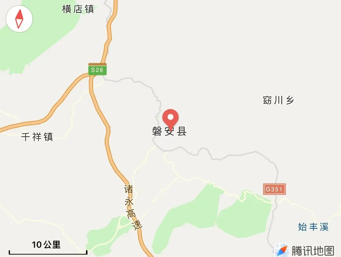
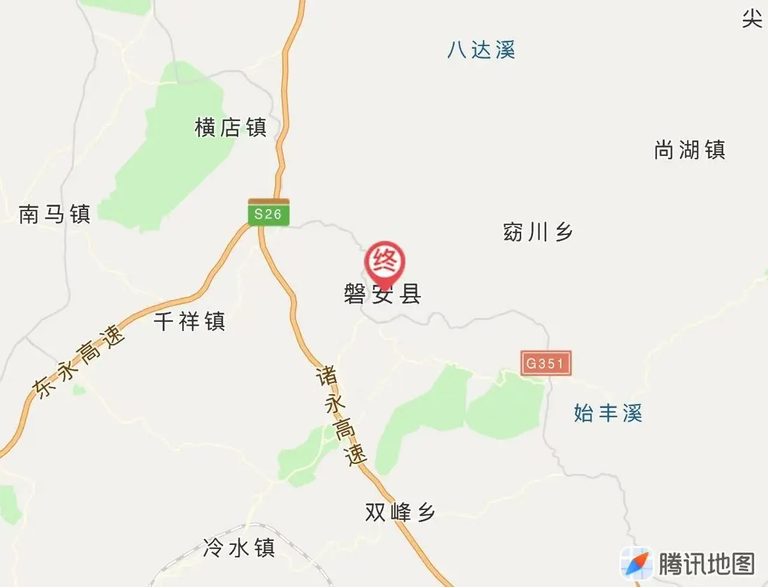
對比Web地圖
第一張是web地圖,第二張是IOS原生地圖
完整代碼
代碼